
You can’t really say you’ve experienced England without a stint in the rain. And I can’t really say I’ve traveled until I take a mildly unpleasant turn of events and milk it for all its nastiness. So it was that I planned a bike ride through the northern Lake District’s scenic hills and dales on what was arguably the worst day of weather during my stay in England.

The Lake District is renowned as a cycling destination. It is home to some of the best scenery England has to offer and a seemingly endless network of country roads and bike trails. Add to that its position at the eastern end of the popular coast to coast (C2C) cycle-way and you’ve got the makings of a cycling mecca. It’s not a cakewalk. With grades surpassing 25%, cycling the District is not for the faint of heart, even less so in a pelting rain.
It was not like I couldn’t have taken steps to avoid the weather. The forecast had been unwavering – rain all morning with a slight chance of less rain in the afternoon. Instead, I purchased a £25 raincoat (marked down from £100!) and damned the predictions.
I chose a route that my Keswick-based rental shop said was a great introduction to cycling in the northern Lake District. It started out along the Keswick Railway Path, hooked up with the C2C, then circled back through the River Glenderamakin Valley, connecting with the neolithic Castlerigg stone circle, before returning to Keswick.

The Keswick Railway Path follows the former Cockermouth, Keswick and Penrith Railway, which was shut down in 1972 before being converted to a pathway. The trail is part of England’s rails-to-trails movement, which aims to convert abandoned or unused railway corridors for the public good.
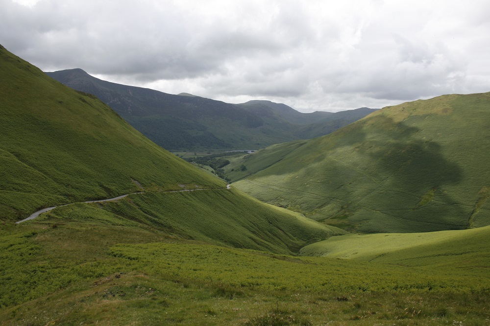
The Keswick trail is nothing if not picturesque, even in a steady downpour. It travels under 19th century tunnels and across eight bridges that span the Greta River. When there was a break in the trees that lined the trail, I enjoyed some spectacular views of the ubiquitous bucolic English countryside and the dominating Skiddaw and Blencathra mountains. At just over 3,000 feet, Skiddaw is the 4th largest mountain in England. That’s not saying much, but when you’re traveling through the tempered English landscape the contrast is striking.

Despite the weather, there was no shortage of outdoor enthusiasts traveling up and down the trail on foot. Hiking, or “walking,” in the countryside is a national pastime in England with entire magazines and websites devoted to the activity. English property laws facilitate the activity by allowing walkers using established footpaths “rights of way” across private property. In some parts of the country walkers are even allowed to roam freely around private property.
Cycling has also developed a following in the UK, although the trend is a bit more recent than walking. Some of this is due to the current success of England’s Tour de France riders, and some due to development of an extensive cycling network across the country. This apparently doesn’t mean local cyclists are ready to abandon all common sense and ride in the conditions I chose to endure. I was the only cyclist on the trail and drenched to the bone after only ten minutes in the open. My £25 coat clearly wasn’t living up to its billing.

The rail-trail ended at the town of Threlkeld, where I meandered through the hamlet until I connected with the C2C trail and headed north along a “gated” road through the Glenderamakin Valley.
Gated roads, I quickly learned, included moving fences that crossed the road every mile or so and required me to dismount to let myself through. I still am not sure whether these gates are meant to separate privately owned lands, control sheep movement, or some combination of the two. I could see the need to keep reins on the sheep. There are an estimated 23 million sheep in the UK, slightly less than half the UK population. As there are few if any sheep domiciled in the major cities, most while away their time not far from country roads like the one I was riding along.

Regardless of their primary purpose, the gates negated any opportunity of getting into a comfortable pace on what were essentially open, empty roads. The consolation for the inconvenience of having to stop all the time was that it allowed me to ride through some beautiful countryside, virtually traffic free.

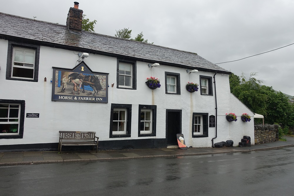
The gated road traveled north for several miles before meeting up with the village of Mungrisdale, a tiny spot on the map whose single claim to fame appeared to be a local pub frequented by hikers and cyclists. As it wasn’t quite noon, and I still had about 15 miles to ride I resisted the temptation. Instead, I circled back toward Keswick along a mercifully ungated road until I got to the town of Scales not from Threlkeld. There, sodden and hungry I enjoyed some good food and ale at the local Whitehorse Inn.
A few ales later, I staggered out of the Whitehorse, intent on making it safely to the Castlerigg stone circle, my final destination before returning to Keswick. A few minutes in northern England’s sobering wind and rain quickly assured me that I was going to be just fine.
You might call Castlerigg the Stonehenge of the Lake District. Built around 3,200 BC, the stone circle is made up of approximately 40 stones (the actual number apparently is disputed) and, like Stonehenge, established to serve some sort of ritualistic purpose. It’s not clear what purpose exactly, although some have speculated that it had something do with blessing stone axes. There’s a certain logic to that. Back then ensuring your tools and weapons functioned properly was probably more important than such leisurely pursuits as shoring up your soul.

What Castlerigg doesn’t share with its neolithic brethren to the south are entrance fees, gift shops, or any pesky rules that restrict access. In other words, it was the ideal stop for a filthy, waterlogged cyclist wanting to take in some pre-history and not look out of place. In fact, the only thing wrong with the site was the 300 foot climb I had to pedal through to get there (“rigg” is old English for ridge). You’d think the local druids could have been more considerate.

Keswick was only about a ten-minute ride from Castlerigg, all downhill. What I probably should have done at that point was return the bike, sit down at one of Keswick’s numerous fine public houses, and continue what I had started at the Whitehorse. Instead, with some time left on my rental, I chose to continue exploring Keswick’s rail-trail, adding another layer of filth to my already grimy exterior. Why step out of character and enjoy myself when I could spend a few more hours in the muck and mire.


Ah, the memories of English rain (and I have only been there in summer!)
LikeLiked by 1 person
Lovely post; have been here once, so reading your post bought back a lot of fond memories!
LikeLiked by 1 person
Thanks. It was a great trip.
LikeLike
Riding fenderless in the rain and wind all day takes a certain level of craziness! I would probably do the same. Cycling is a compromise between walking and driving to see the countryside.
LikeLiked by 1 person
Fenders, what a concept. They would have come in handy.
LikeLike